Kirkstone Park multi-use path
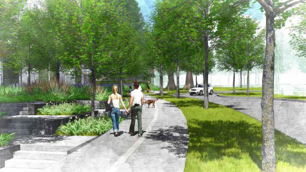
We are building a multi-use path (a path shared by people walking and people on bikes) to connect Kirkstone Park with Emery Place. The pathway and landscaped area will be approximately 140 metres long, and 6 metres wide (3 metres for the pathway, and 3 metres for a planted boulevard).
To the north of the path, there will be a new local road that includes two travel lanes for vehicles, a parking lane (on the north side), and a landscaped boulevard and sidewalk.
News and updates
July 29, 2020 — Tree removal
Additional tree removal is required to make way for the new road and multi-use path at Emery Place. These include the trees currently located in the centre of the roundabout as well as two Chestnut trees on the south side of Emery Place.
A bird nesting survey has been completed for this work as is required at this time of year. No active bird nests were identified in the trees slated for removal.
February 14, 2020 — Tree removal
Tree removal is required to facilitate the construction of an extension of Emery Place and the new multi-use path connecting Kirkstone Park with Emery Place.
Arborists have identified 42 trees that will need to be removed, including two trees that are dead.
For the safety of the public, the existing path connecting Emery Place to Kirkstone Park will be temporarily closed during this work. Signs with details about alternative routes are installed near the park entrance.
Tree cutting will be completed before March 1, 2020 — prior to the start of the bird nesting season — with remaining work such as stump and debris removal to follow.
December 13, 2019 — Public survey results
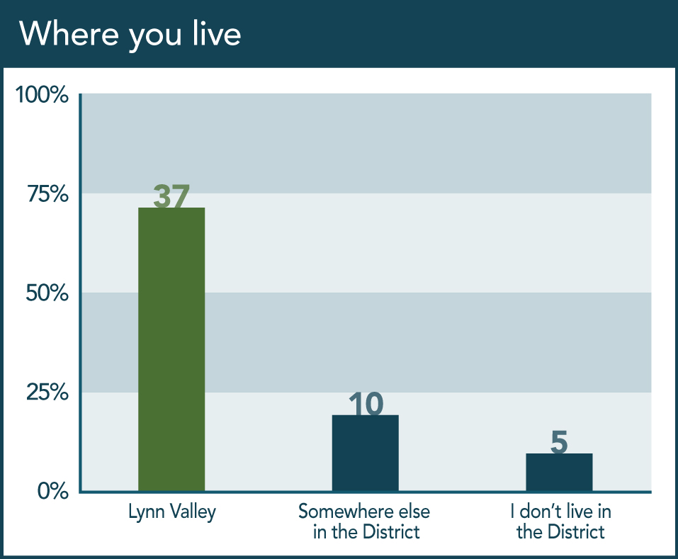
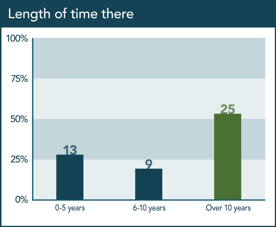
Between November 26 and December 10, we hosted an online survey to gather input from residents about their preferences for the multi-use path, and promoted the survey on our homepage, through social media, and with area signs.
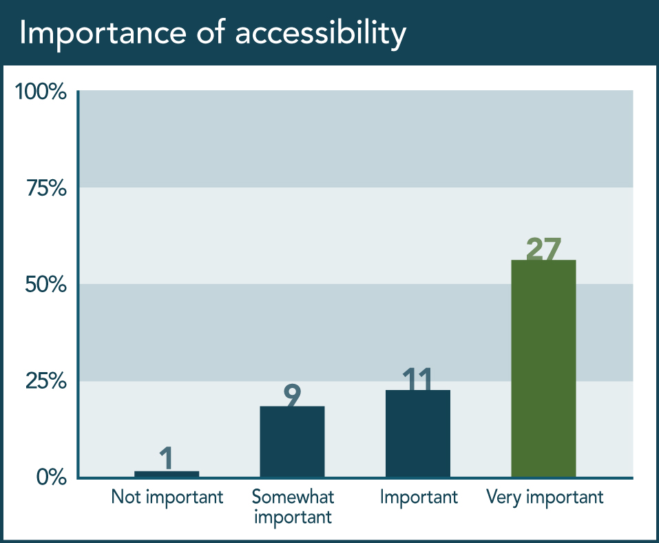
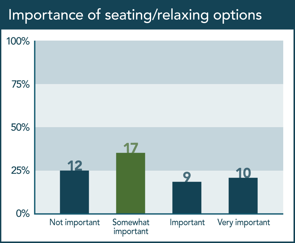
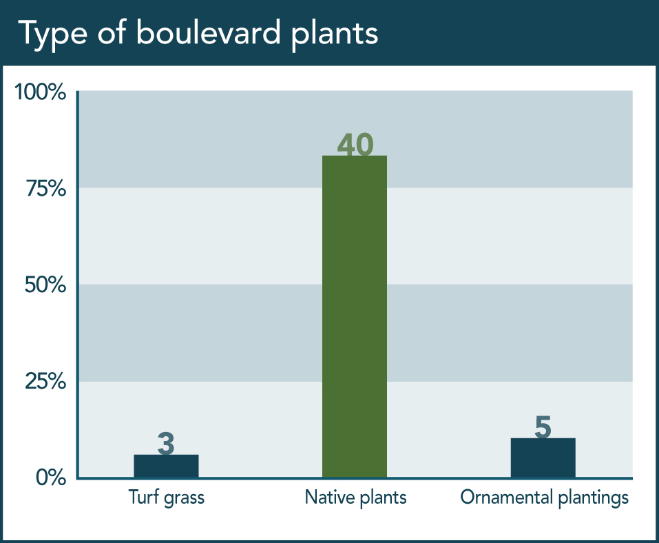
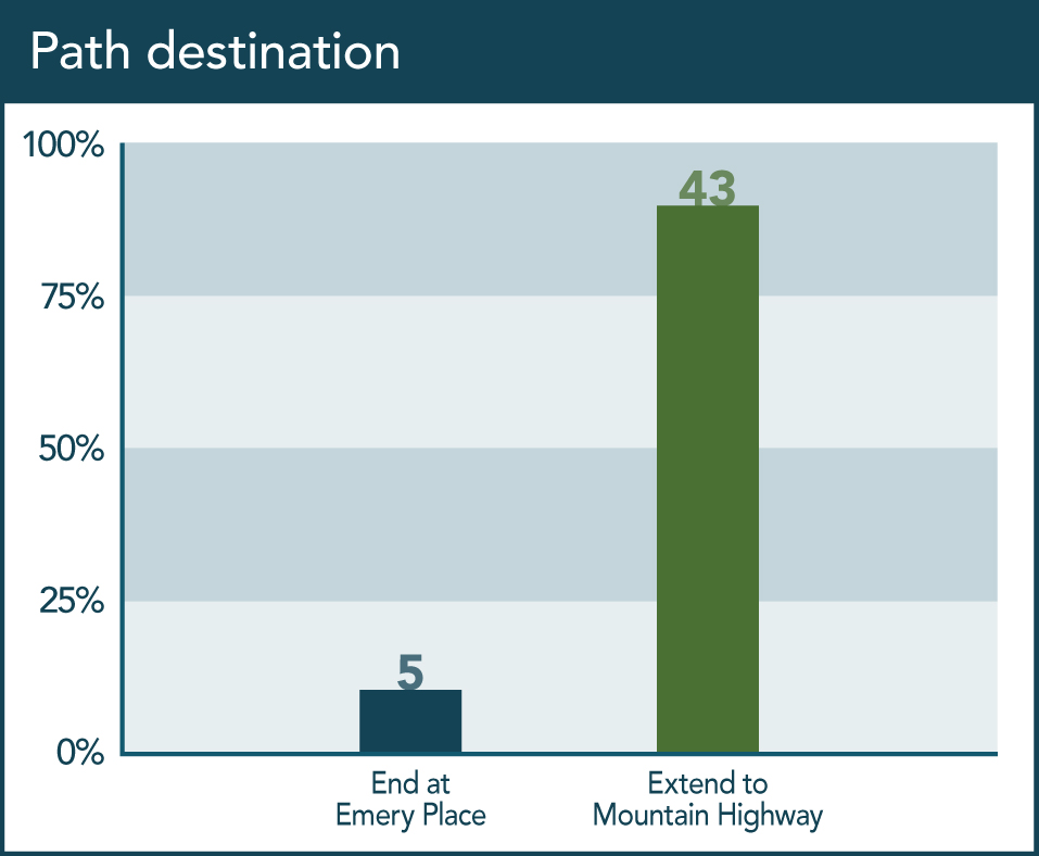
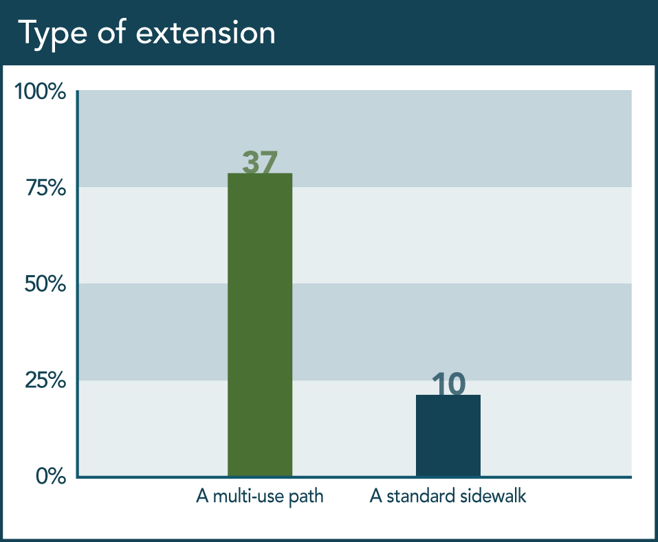
We asked about accessibility, features, types of plantings, and the possibility of extending the path to Mountain Highway instead of stopping at Emery Place. 57 people took the survey, though not everyone chose to answer every question.
Here is a summary of what we heard:
- 56% said it is "very important" that the path be accessible to people of all ages and abilities
- 35% said it is "somewhat important" that the path provide opportunities to rest and relax
- 83% said they preferred native plants for the boulevard
- 90% said the path should be extended to Mountain Highway
- 78% said the extension should be a narrower version of the multi-use path
Want more details? Select any graph to view a large version (each question has a corresponding graph showing all responses), and to scroll through all the graphs.
November 26 to December 10, 2019 — Public input
To help us build a multi-use path that works for everyone, we collected feedback from the community on the potential design for the path. We will add a summary of responses to this page the week of December 16, 2019.
Drawings and photos
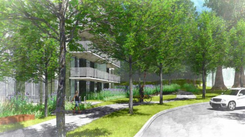
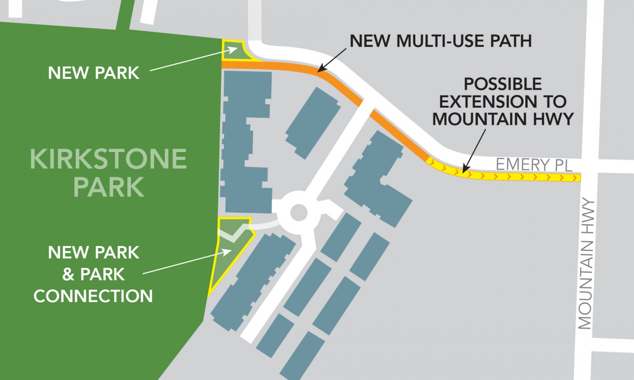
This graphic shows the location of the new path, and includes a potential extension to Mountain Highway. It also shows new park space that has been added to Kirkstone Park.
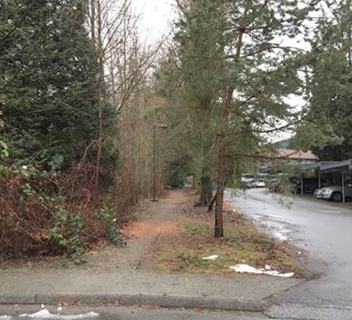
This photo shows the path between Emery Place and Kirkstone Park as it appears now (end of 2019).
Related web content
Background
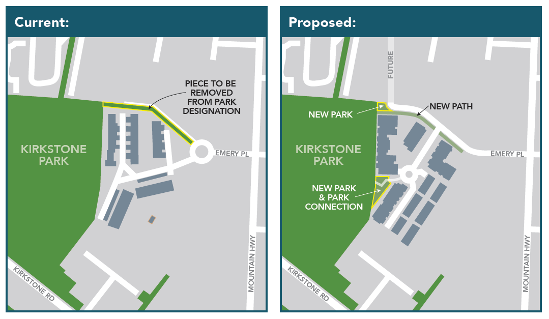
In early 2018, Council used an Alternate Approval Process to seek approval to remove a strip of Kirkstone Park (6 metres wide and 140 metres long). This strip of park, on the north eastern side, is an unpaved pathway adjacent to a paved road, and leads to Emery Place from the park.
About the Alternate Approval Process
An Alternate Approval Process is rarely used, and only when timing is critical and there is an appreciable benefit to the community at stake.
As part of this process, Council were able to vote to remove the piece of land from park dedication, as less than 10% of District electors signed and submitted elector response forms by the March 12, 2018 deadline.
These illustrations show the area as it was previous to the Alternate Approval Process, as well as the change that was proposed.
Alternate Approval Process timeline
July 23, 2018 — Adoption
Council voted to approve the changes proposed under the Alternate Approve Process.
April 4, 2018 — Public meeting
We hosted a public meeting for residents, to answer questions about potential impacts to Kirkstone Park. District staff were on hand to answer questions and take comments.
March 12, 2018 — Last day for public input
The deadline for a resident to submit an elector response form indicating they did not wish the piece of land to be removed from park dedication was 4pm on Monday, March 12.
February 1, 2018 — Elector response forms available
As part of the Alternate Approval Process, we made elector response forms and details of the proposed change available online. Residents were invited to complete and submit a response form if they did not wish this piece of land to be removed from park dedication.
January 29, 2018 — Alternate Approval Process
Council passed a motion to use an Alternate Approval Process to remove a sliver of Kirkstone Park from park dedication.
Documents related to the Alternate Approval Process
Notice of alternative approval process
Elector response form for Bylaw 8303
Related Council documents
Council adoption of the proposed changes, July 23, 2018
Agenda report from the January 29, 2018 Regular meeting of Council